The Green Approach
PCG is Not the Green Way
PCG/PATH proponents like to promote their “greenways” as, well, green. Including what they plan for Henderson Mill Creek (HMC). However, we’ve seen what these groups did in Section1 of the Peachtree Creek Greenway (PCG) and it was far from “green.” They cleared a 20-50 foot wide swathe along the length of the creekbank and laid down 3 acres of concrete. What was originally a dense, absorbant, inhabited forest canopy is now home to 14ft wide concrete with large areas on either side completely cleared and replanted with mown, manicured lawn grass. Local officials only required a resultant tree density of 120 dbh inches per acre - this is fewer trees than most of us have in our yards! And although Section1 is peppered with signs saying “Wildlife Habitat,” the reality is that there is no habitat remaining… unless you are a duck.
A True Green Way
A true green approach to the floodplain lining the creek would be to preserve it. Work to improve it, restore it, and let it remain for the public to see and learn about. There are ways to construct actual nature trails that are far less destructive to the floodplain. This is what an original study commissioned by Mercer recommended, and it is what we support.
If biking connectivity is routed via a Flowers Road sidepath, then Mercer is free to both manage the HMC floodplain and allow neighbors to experience it in this far more ecologically oriented manner.
Floodplain Nature Preservation and Education
We would love for Mercer to find a way to accomplish its objectives for the HMC area without allowing PATH’s concrete road, instead doing something that enhances the creek floodplain rather than forever altering it with a concrete road.
HGOR’s 2015 study, which emphasizes preservation, restoration, and education, seems a conceptual step in that direction. One of our neighbors is retired from a company that has 18 natural habitats certified by the Wildlife Habitat Council (https://www.wildlifehc.org/). The certification process involves design of a habitat prioritizing conservation, education and community involvement. Some of the company’s habitats are described here: https://www.shellyco.com/sustainability/wildlife-habitat-sites/. Other environmental organizations also offer similar certifications, for example the Georgia Native Plant Society: https://gnps.org/habitat/.
These certifications are a concrete (pun intended) means to value the habitat, and to emphasize ecological approaches to preserve it. Mercer’s own 2015 HGOR study is focused on this type of mindset:
- “No other institution in Atlanta has the same opportunity for impact on the riparian systems at such a meaningful point at the headwaters of the watershed.”
- “The program could be developed as ‘The Mercer Method,’ utilizing the site as a living laboratory, and providing needed guidance and impetus to others within the watershed and region to systematically restore a fully functioning urban riparian-based ecology.”
An approach such as this, prioritizing preservation, restoration and education is what we’d love to see in replacement of PATH’s goal of simply finding a means to lay pavement. This conservation mindset would invite nature trails and educational facilities with minimal impact on the habitat.
Nature trails and footpaths
PATH’s concrete swathe is a very poor way to experience the floodplain. It is not a place to stop and look, experience or explore. You can’t do this because the route will be raised and railed, completely separated from the floodplain floor, with the flora and fauna totally out of reach. PATH doesn’t particularly care since they don’t want you to stop to look around anyway. Their own “trail etiquette” page states: “Keep right and pass on the left - the trail is like a roadway,” and “If you stop, get off the trail.” With the bike road being raised (possibly a story high per the artist rendition) and railed, you cannot easily get off which means… you aren’t supposed to stop. This bike road is not intended for exploration or education or even relaxation. It is intended as moving thoroughfare to traverse the floodplain.
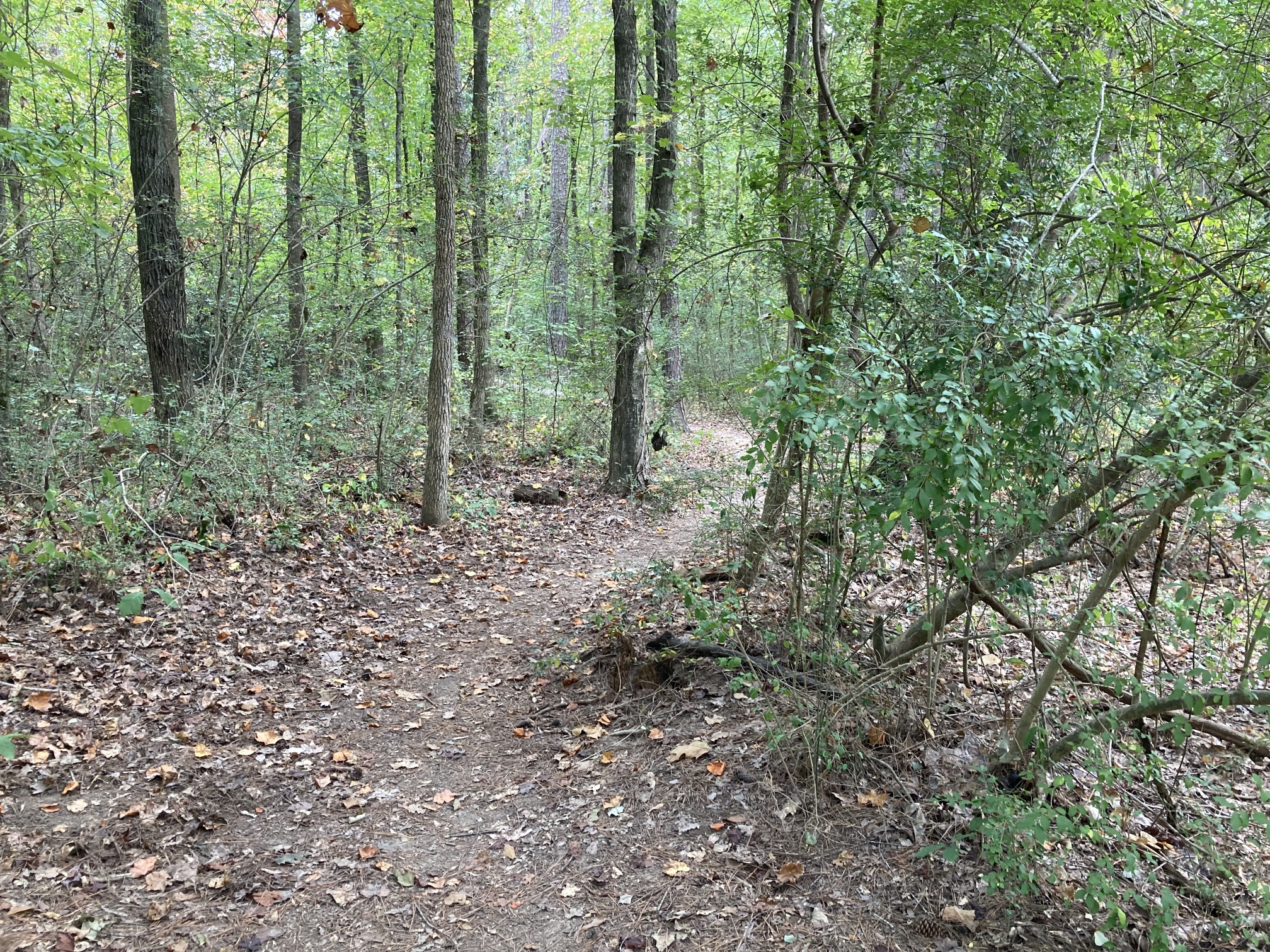
Mercer's Cecil B. Day Trail
Ironically, every proponent that we’ve heard speak of the flood plain talks about the beauty that is only visible on foot, on the ground, immersed in the habitat. The tracks of the wildlife, the impressions left by sleeping deer, the nesting areas, perhaps a fox, a beaver, an otter, the wetlands flora, the turtles and snakes… all of the habitat is available on foot, on the ground, in a low-traffic, slow environment. These things cannot be seen, smelled, or touched from PATH’s proposed elevated, concrete route. PATH’s approach is the wrong approach, and it will not give proponents what they claim they want.
We have stated many times that the HMC floodplain can be explored on foot, as-is. Many of our neighbors do. It is seasonal, but it is quite doable and very beautiful. That said, we do understand that this may be a little intimidating for some. And so we are proposing a small footpath, a true “trail”: 2-3 feet wide, dirt, winding its way amongst the trees and scrub. Something similar to Mercer’s Cecil B. Day Trail. This type of path would not damage the habitat. It is low-impact, low-traffic, non-invasive, introduces no foreign materials, and requires no heavy machinery. It would allow our neighbors to experience the area in a slow, thoughtful, and educational manner, taking their time to fully immerse themselves.
Every PATH proponent that we’ve heard speak about the floodplain, describes it in a way that can only be experienced on the ground. They talk about the things that cannot be seen, smelled, or touched from PATH’s proposed elevated, concrete route. The concrete bike road is the wrong approach. Instead, we propose an exploratory nature trail, on the commercial side in the drier areas. A trail in the true sense of the word. One that allows you to see the true wonder of the habitat in the best way possible - on foot, on the ground, in a low-traffic, slow environment.
There is no need for a 12’ wide, raised concrete swathe to learn about this beauty. All you need are your feet and a small trodden path. Simple, cheap, non-invasive, and incredibly effective.