Objections
HM Creek Commercial Side
Residential
Much of this route backs directly onto single family houses. Many single family homes. Along practically the entire route. These homes were purchased specifically because the back yards are quiet, serene woods with abundant local wildlife that was supposed to be safe from any construction of any sort because it is a wetlands/flood plain area. It will be invasive, loud, and destroy all privacy to put this bike route behind the homes that border the creek.
“Commercial Side” of the Creek is Not a Good Solution
PATH/Dekalb’s response is that they will construct this bike road on the opposite side of the creek, where the commercial buildings are located (apartments and Strayer University campus). They claim that “it won’t disturb you” from that side of the creek. This is not true. The commercial side properties directly abut the forest/flood plain. There is no already-cleared area behind these buildings/parking lots in which to put a bike route. PATH will still clear out a large swath of the wilderness beside the commercial side of the creek in order to put in this bike road. It will damage the habitat, drive out the wildlife, and permanently alter the serene beauty of the wilderness even if the bike road is built on the commercial side.
The home owners on the residential side will see this even if PATH builds on the commercial side. The entire floodplain area is quite narrow, and most of the homeowners can easily see the trees and grasses on the commercial side as well as on the residential side. Clearing out and constructing a raised, concrete bike road through the commercial side of the floodplain will be visible and audible to the homeowners. The destruction in the habitat on the commercial side will be apparent to the homeowners. It will still affect your privacy, your view, and your currently peaceful back yard despite PATH’s assurances that it will not.
Urbanized Design is Highly Obtrusive
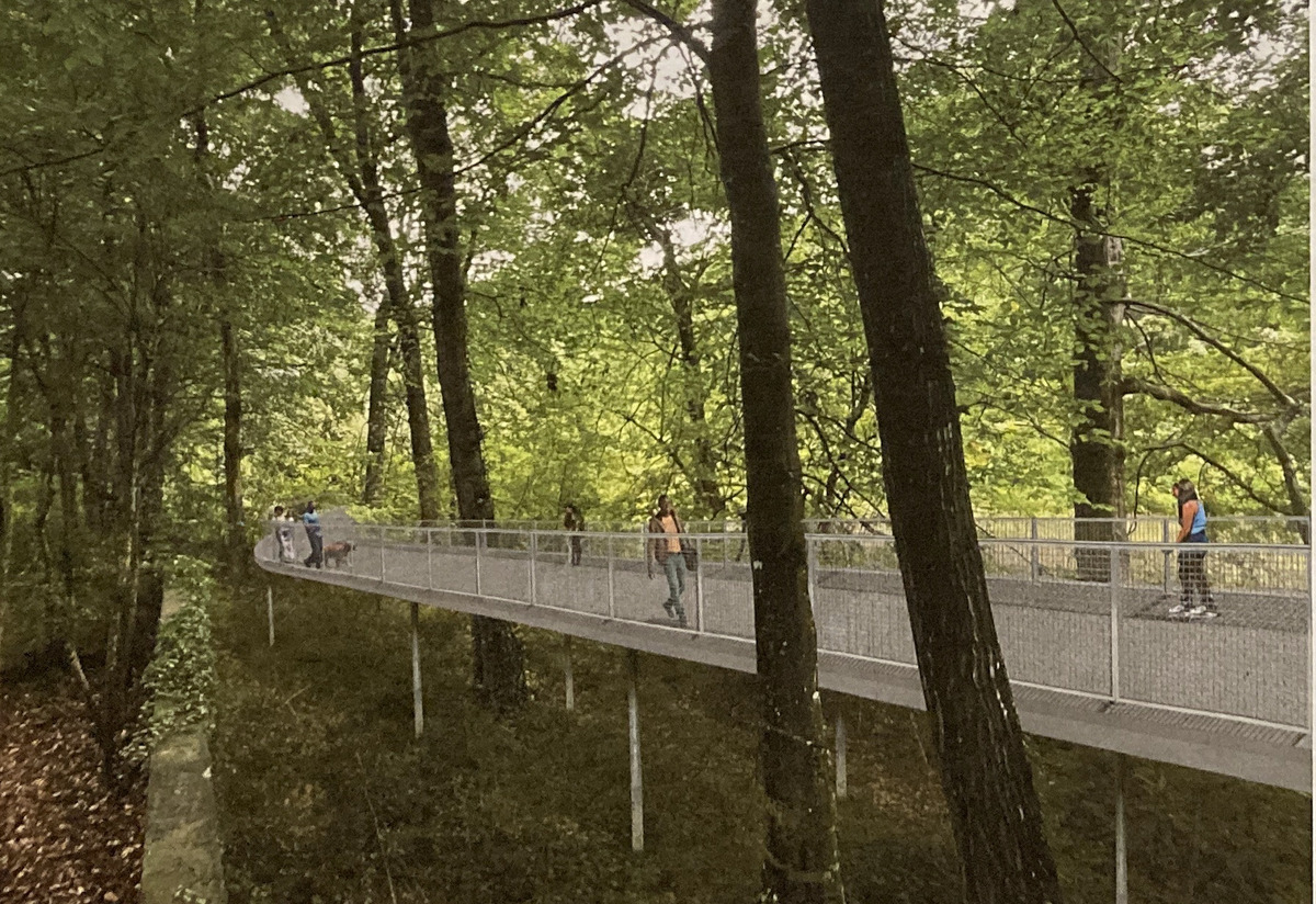
Artist Conception of the Raised Road
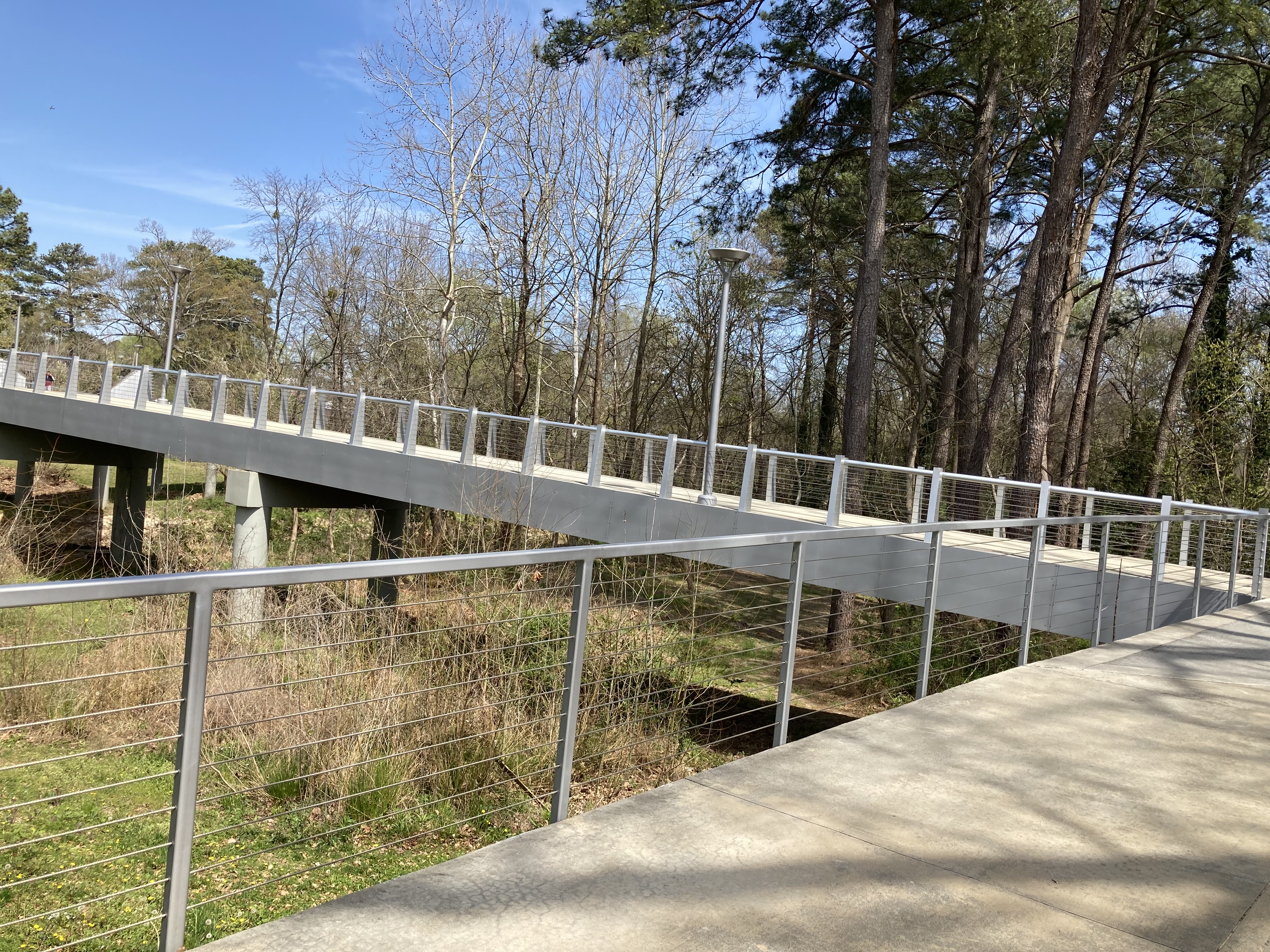
Reality: PCG Bridge in Model Mile
It’s clear from PATH’s artist conception that they have no intention whatsover of trying to blend their bike road into the natural surroundings. It is raised, concrete, and silver steel railings and posts.
At first we thought this couldn’t really be what they were planning for such a beautiful natural space… and then we saw the reality. The concrete and steel bridge that PATH built for the Peachtree Creek Greenway (PCG) Model Mile is even worse!
PATH’s PCG design creates a highly urban city look instead of trying to blend into the natural surroundings. We don’t want the bike road at all, but we certainly don’t want one that looks like it belongs in New York City.
Narrow
The floodplain area is very narrow. There is not room to support clearing the forest for a 12’ wide bike road without destroying much of the local habitat. In many areas, the creek is within 40 feet of the commercial side parking lots, and this bike road is expected to be 12’ wide with 2-5’ clearance on either side. In many places there will be little left of the habitat once PATH clears the trees for the bike road. And yes, PATH will clear trees regardless of what they claim in the presentations. Most of the area is a dense forest. There simply is no way to place this concrete swathe without removing trees in order to make space.
Because the floodplain is narrow, PATH will place this bike road very close to the creekbank. Just do the math - if the creek runs only 40’ from the parking lot in many areas and the bike road+clearance will take 16-22’, then this concrete swathe will be placed within 10-20 feet of the creek itself in many places. PATH has never publicly stated just how close to the creek they intend to go, but we can figure it out. This is far within both the state and county riparian buffer zones. Not only will trees come down, but the area taking the brunt the damage is going to be the fragile, and frequently flooded, creekbank.
As well as the ecological concerns, there are residential homeowner concerns caused by the narrowness of this strip of land. The homeowners on the residential side of the creek will still be affected even if the bike road is placed on the commercial side of the creek. As stated above, the route will run practically next to the creek in many places, and it will be raised and highly obtrusive visually.
In the 9/27 presentation, PATH measured distances in the floodplain in a way that makes the flood plain appear wider than it really is and the bike road further from neighbors than it really is. PATH measured to our houses instead of to our property lines, ignoring that fact that a property owner’s right to quiet enjoyment extends through their yards. PATH also measured the commercial side to Flowers/Brandywine Roads instead of to the actual back of the developed commercial properties, making the commercial side of the floodplain also appear much wider than it actually is.
Using these skewed measurements, PATH repeatedly emphasized that the route would be on average the length of a football field (300 feet) from the residential homes (and far closer to our back yards). Of course, averages don’t show anything about the wide range of distances. The reality is that the floodplain is not regularly shaped. Some areas are wider and others are far more narrow. Many homes are much closer than this 300 feet, and multiple homes’ yards will actually abut the bike road.
When the true proximity of the homes was brought up in the meeting, Eric Ganther, PATH’s representative, responded that “a tall unclimbable retaining wall would be constructed and a fence would be placed at the top.” How is this ecological? How is this not invasive? How is this considerate of neighbors backing this bike road? The answers - it is not.
Ingress/Egress points at Cravey and Rangewood
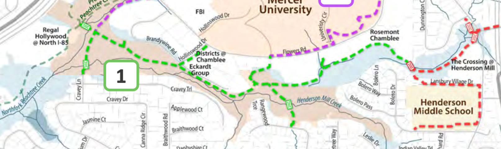
Neighborhood Ingress/Egress
The new proposed “trailheads” at Cravey Ln. and Rangewood Dr. will abut private residential property. PATH claims that nearby residents won’t even know the bike road is there. These access routes render that claim blatantly untrue.
The access points will attract traffic onto quiet neighborhood streets that currently host minimal residential traffic. They will also provide easy access from and into neighborhoods – nice entrance and escape routes for anyone with ill or reckless intent. Parking near the access points will be disruptive and chaotic to nearby residents. The homes adjacent to the access points will be far closer than the 300 feet claimed by the PATH representative. The nuisances created by the access areas will cause these homeowners to lose the peaceful enjoyment of their properties, and undoubtedly deflate their property values.
Dwindling Natural Habitat
This floodplain is one of the few remaining wilderness areas ITP where native wildlife can still manage to survive and thrive. The area is not large, but it is home to deer, fox, beaver, coyotes, turtles/tortoises, frogs&toads, snakes, hawks, heron, geese, ducks, otter and some neighbors claim even a bobcat. A vast abundance of tree frogs and other amphibians including salamanders, also crayfish. Birds include hawks, barred owls, an assortment of woodpecker varieties (Pileated, Downy, Red-bellied), and a wide range of smaller birds. In fact, this area is considered a local birding hot-spot.
It’s a beautiful ecosystem, and PATH will permanently damage it with this bike road. The wildlife will not remain after this type of disturbance. The flora will be affected and the tree canopy as well. There is a reason that the state and county created riparian buffers, and PATH will breach it throughout this tract. The water may flow under when PATH piers the concrete, but the ecosystem will still be damaged. This habitat is an increasingly rare jewel in our urban environment, and it should be be protected and preserved in its quiet, secluded, natural state. Rather than overrunning it with an invasive, concrete, high-traffic bike thoroughfare, we should be focused on restoring and preserving it.
Clearing the Woodlands to Create An Artificial City Park
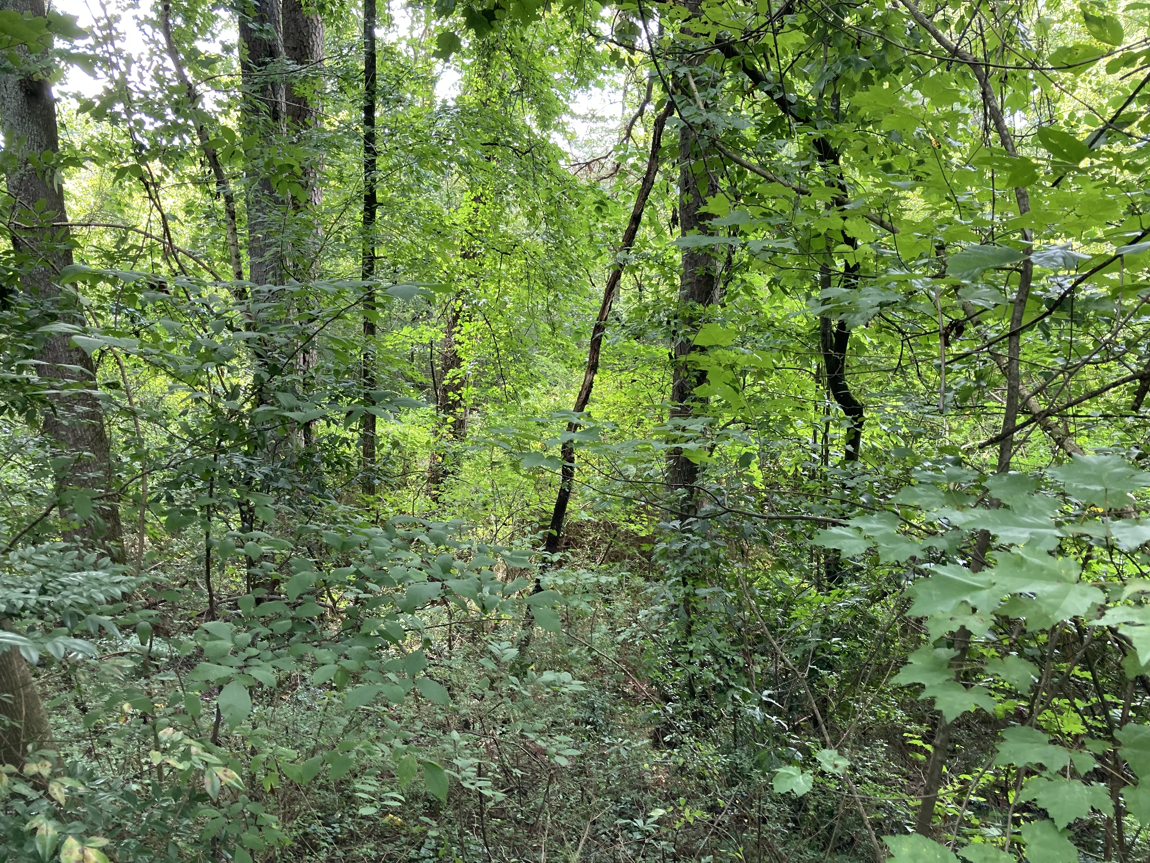
Peachtree Creek Greenway
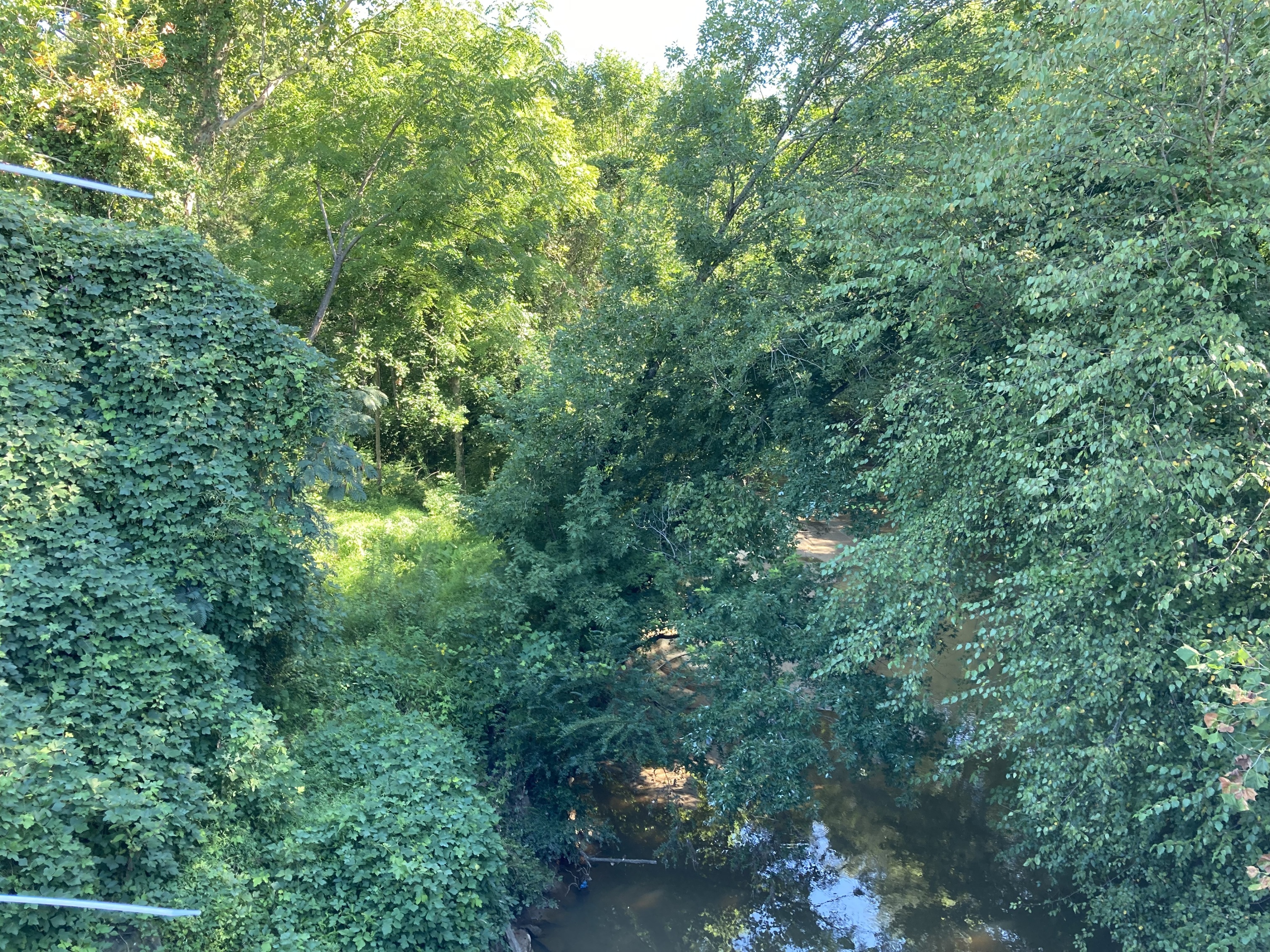
Peachtree Creek - NATURAL STATE
PATH promotes their newest “Model Mile” (“first section”) of the Peachtree Creek Greenway as a model for the rest of their trail system. (It is located behind REI off of the I-85 access road just off of Briarwood.) They directed us to go look at the route when we questioned what exactly they were planning to do to Henderson Mill Creek. The Peachtree Creek Greenway area is practically clear-cut! This greenway has cleared out 60-75% of the natural habitat along North Peachtree Creek. There is mown grass, small (? newly planted?) trees, and a very wide concrete road. Definitely not a “trail.”
We took out our measuring tape, and measured actual distances along the route:
- Width of the concrete: 14 feet throughout
- Width of the cleared area on the creek side of the concrete Varies: 40ft, 25ft, 28.5ft, 36ft. Overall, the cleared area is about 25ft+ up to 40ft.
- Width of remaining natural habitat along the creek: Varies: 7ft, 21ft, 11ft, 6ft, 20ft, 7ft. A couple areas do reach 20ft, but most are less than 15ft and many less than 10ft. Nowhere does the remaining natural habitat reach 25feet, which is what is required for all homeowners seeking to even trim natural vegetation along the creek!
Take a look at the Creek just north of the Briarwood Road (the “NATURAL STATE” image) to see what the natural habitat along the creek bank really looks like, and think long and hard about how invasive PATH’s model Greenway actually is. Then imagine PATH doing something similar to the Henderson Mill Creek floodplain. PATH’s bike road cleared out a 40-55 foot swathe of the creek bank, leaving on average maybe 15 feet. That is 60-75% of the natural habitat cleared and replaced by a pristine, manicured “city park” (think Piedmont Park). We do not want the Henderson Mill Creek wetlands changed in this way!!
We do understand that this model Greenway looks pretty, and if you don’t realize what the costs were… you probably would like it. But please put this in the perspective of destroying a beautiful native wetlands when you consider whether or not you would want the Henderson Mill Creek changed like this. We do not. We hope you do not as well.
12 Feet is Wide
Two Corollas Wide
At the second (9/27) public meeting, the PATH representative made a big point about how they no longer consider the first section of the greenway as representative. He blamed it on Brookhaven. (This is only 4 weeks since the proponents had used that section as an exemplar!) He assured us that PATH’s current recommendations are for “only” a 12 foot wide concrete path, and that the path would elevated on piers since they are building over a floodplain. (Please keep in mind that the first section of the PCG is also built in a floodplain. Would PATH have planned the same for Henderson Mill Creek if we hadn’t made an outcry?)
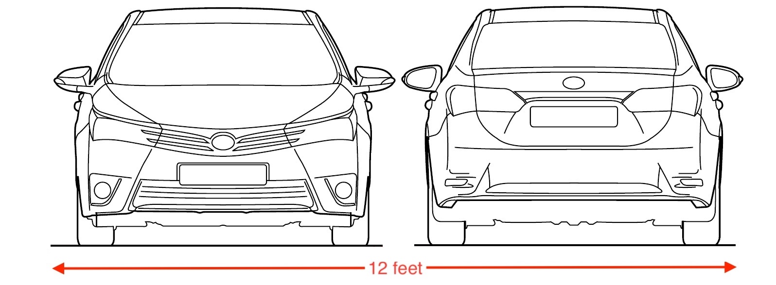
In any event, 12 feet is still a huge width of concrete. In order to visualize just how big this is, consider a typical mid-sized sedan - the Toyota Corolla. It is 70" wide. You could park two Corollas side by side on this proposed “bike trail”:
How much environmental impact is there from a 12 foot width of concrete shading the forest floor? Radiating heat in a wetlands? How much water runoff will there be, and how will that affect erosion / damage to the ecosystem? How many trees will be removed to clear enough space for 12’? What happens in the places where there is only 40’ available next to the creek - will they actually remove trees that cover 1/3 of the habitat width to make room? How much will the large-scale construction equipment for such an invasive route affect the area?
Not a Trail
Terminology matters. PATH calls this a “trail” and a “path,” but it is neither. This is a bike road. It is 12’ wide concrete - wide enough to fit 2 Toyota Corollas side-by-side. A “trail,” as the term is commonly used, is a 2-3’ wide foot path through a forest. PATH’s 12’ concrete route is about 5x wider than a “trail.”
What PATH will build is, essentially, a road.
Invasives and Debris Management
PATH repeatedly claims that building this bike road will magically help resolve the problems in the floodplain - invasives, debris. We don’t deny that these problems exist, they do. And we would love for both Mercer and the apartments to take a conservational approach to the area and work toward cleaning the debris, clearing the invasives, and restoring the native plant-life. But this takes work. PATH’s claim that its raised, elevated bike road that isn’t even accessible to the ground will somehow fix these ills is nonsensical. What will fix these ills is an ecological assessment, plan, and restorative work - all of which neither require nor benefit from a raised bike road. And none of which will be done by PATH.
Concrete
They call it multi-use, but it is not. Concrete is a very bad surface for pedestrians. It is far too hard, and will over time will damage knees. Runners, joggers and longer-distance walkers avoid concrete, using asphalt roads instead. PATH does not deny this. PATH simply states that for maintenance reasons, they will only use concrete.
The only traffic which is safe for repeated and/or distance use on concrete is wheeled traffic. This road is intended for bikes.
The concrete also sticks out like a sore thumb. It is artificial, unnatural and doesn’t fit into a beautiful floodplain/wetlands such as Henderson Mill Creek. A raised concrete slab like this will be an eyesore.
Security
PATH says the bike road will only be open dawn to dusk. Who will enforce those hours? Who will patrol the almost one-mile length of bike path? Certainly not PATH. PATH has repeatedly stated that all security issues will be on Dekalb.
The alternative, a bike route along Flowers Road would be far less problematic. It would be visible from a quiet, but not deserted road. There will be many more eyes on a Flowers route than on a route through the floodplain.
Lights
PATH initially stated the route would be lit, but in the 9/27 presentation Eric said that perhaps they would us some sort of “dark sky” lighting (no details provided). Much of the floodplain’s wildlife is nocturnal. Any sort of lighting will disturb what little wildlife remains after construction. Lighting in an ecosystem like this is detrimental to the wildlife and will also impact the single family homes on the other side of the creek.
Flood Plain

Flooded HM Creek 2019
Henderson Mill Creek fork is a flood plain, and not just in name. It does frequently flood. Much of the area can be underwater with heavy rains, and in fact some of it has been permanently underwater for long periods. The area behind our house was underwater for at least 15 years out of the 23 we’ve lived here.
If this area becomes permanently inundated again, then this raised route would be like putting a road end-to-end lengthwise through a river. It is true that roads are sometimes built to cross rivers and streams, but nobody should intentionally run one through the length of it.
A concrete bike road, raised or not, does not belong in this flood plain.
Cost
Clearly the cost of adding a bike path along Flowers Road would be far less than what PATH will spend in clearing a route through floodplain, and constructing this elevated concrete bike road. Why is all this money being wasted when there is a much more cost-effective and non-intrusive alternative?
Ecological Impact
PATH’s bike road through the floodplain will have a huge impact on the habitat. It may not be all wetlands, but much of it is. And even the areas not designated wetlands can still be very wet. It is a beautiful, fragile area with abundant wildlife, yet it is also small and narrow. The type of heavy construction that PATH plans will permanently alter it. PATH will clear a lot of habitat, remove a lot of trees, and lay concrete. Much of this activity will be done very close to the creek bank, well within the riparian buffer zone. This clearly will have a significant ecological impact. Now compare this ecological impact to 0. There will be 0 damage to done to the floodplain if PATH stops this nonsense and builds their bike path along Flowers Road.
PATH Does Not Discuss These Problems
PATH never discusses these concerns when presenting. Are they afraid of pushback if people actually understand the cons to their proposals?
Tell PATH you DO understand the negatives of developing in the floodplain, and that you DO NOT want them to do it. Not on the homeowner side and not on the commercial side. JOIN US!